Although the beginning of summer welcomed us with Pleasant temperatures for the time of yearthe situation has already changed. With the arrival of the month of July, and especially in the last few daysthe heat has been felt in practically all parts of the country. A first heat wave of short duration, Now, another one follows.
The week of July 22 to 29 will be warmer than normal in almost all of Spain, especially inland, the State Meteorological Agency (AEMET) warned yesterday. And, just a few hours later, they confirmed the arrival of a second episode of high temperatureswhich will leave us figures between 40 and 42C both in the center and in the south of the peninsula.
Through a special notice, AEMET has reported this new heat wave, which start this Tuesday and finish next Thursday. However, although there will be a thermal decline from that day, Intense heat will continue to be present in several areas of the country. This heat wave, the agency explains, comes after the displacement of the African anticyclone at medium and high levels over the peninsularesulting in great atmospheric stability.
But it is not only due to this factor. It also influences the high sunshine at the time and the absence of cloud cover and light or calm winds. All this together will produce an increase in temperatures starting this Tuesday, with values especially high in areas of the center and south of the peninsulaOn Wednesday, which will be the peak day of this heat episode, the situation will occur over a larger area of the national territory.
Intense heat until Thursday
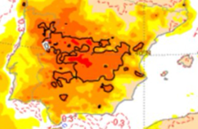
As, for this Tuesday a Increase in temperatures, both day and nightwhich is larger in the Ebro valley. The maximum temperatures will be above 40C in the valleys of the Tajo, Guadiana and Guadalquivirin addition to the Genil basin. More heat will arrive in the Cordoba countryside, with highs of up to 42C. Something below will be in the southern Galicia (up to 39C)in the southern plateau and the rest of western Andalusia (between 37 and 39C) and in the south of the northern plateau (36C).
Wednesday the heat continue to be present, and will do so in a larger part of the territory. Thus, it is possible that maximum temperatures of 40-42C generally in the center and southwestern quadrant of the peninsulaeven reaching 44C in the Guadalquivir valley. High values will also be recorded in the Ebro Valley and the interior of Valencia (39-40C)the interior of the southeast of the peninsula (38-39C) and the south of Ourense and the northern plateau (37-38C).
The nights, moreover, will be especially warm in the river valleys of the southern half and in those areas affected by land winds, exceeding the 22C and even 24C locally on Wednesday and Thursday nights. For that day, AEMET predicts a slight drop in temperatures in the southwestern third, although its magnitude and extent is still unknown.
Despite this, the mercury will continue to leave temperatures that will be around 40 degrees, especially in areas of the central peninsulathe lower area of the Guadiana and Guadalquivir valleys and in the Ebro valley. Looking ahead to the start of the weekend, on Friday it is likely that temperatures continue to decline, especially in the southeastern third of the peninsulaAnd although by then the conditions for it to be classified as a heat wave will no longer exist, temperatures will remain high in many areas, especially in the interior of the peninsula, particularly in the centre.
Follow the AS Newspaper channel on WhatsAppwhere you will find all things sport in one place: the latest news, the agenda with the latest news on the most important sporting events, the most notable images, the opinions of the best AS journalists, reports, videos, and a bit of humour from time to time.