
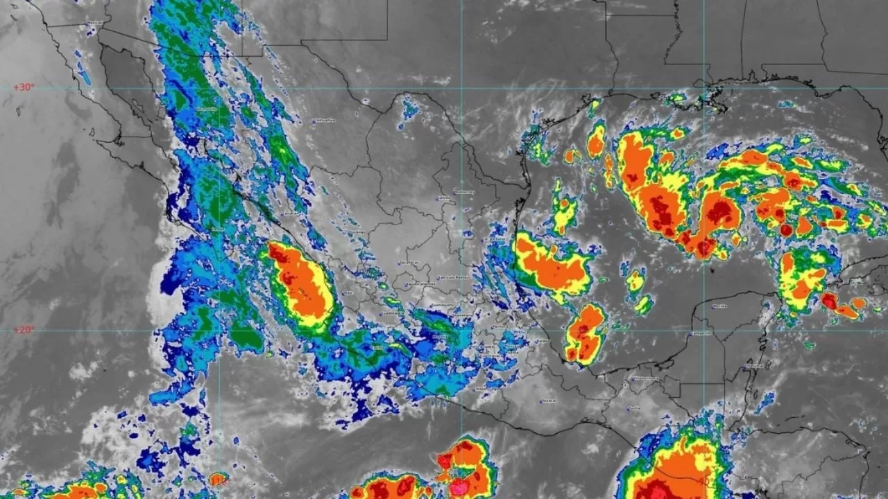
MEXICO CITY (apro).- The National Meteorological Service (SMN) of the National Water Commission (Conagua) forecast very heavy rains in Tamaulipas, Tabasco, Oaxaca and Chiapas.
Tropical wave number 24 will move over the Mexican southeast, in interaction with the entry of moisture from the Gulf of Mexico and the Caribbean Sea, it will produce heavy to very heavy rains in said regions.
On the other hand, the proximity of a low pressure area with a cyclonic probability over the northeast of the Gulf of Mexico will encourage the entry of humidity, generating showers and heavy occasional rains in the northeast and eastern Mexico, as well as very heavy rains in Tamaulipas.
The Mexican monsoon over the northwest of the country, in interaction with a low pressure channel that will extend over the north, west and center of the Mexican territory, will cause showers and heavy rains in the aforementioned regions.
The rains described above will be accompanied by electric shocks, gusts of wind and possible hail fall.
Tropical wave number 23 has stopped affecting the national territory. The very hot environment will continue over the northwest, north, northeast, east and southeast of the Mexican Republic, as well as in the Yucatan Peninsula.
Rain forecast:
strong to very strong: Tamaulipas, Veracruz, Oaxaca, Chiapas and Tabasco.
Intervals of showers with heavy rains: Sonora, Sinaloa, Nayarit, Guerrero, San Luis Potosí, Hidalgo, Puebla, Campeche, Yucatán and Quintana Roo.
intervals of showers: Chihuahua, Coahuila, Nuevo León, Zacatecas, Durango, Jalisco, Colima, Michoacán, Guanajuato, Querétaro, Tlaxcala, State of Mexico, Mexico City and Morelos.
isolated rains: Baja California, Baja California Sur and Aguascalientes.
The rains will be accompanied by electric shocks, strong gusts of wind and possible hail fall.
In addition, heavy, very heavy and intense rains could reduce visibility, cause an increase in river and stream levels, as well as generate landslides, floods and waterlogging.
Forecast of maximum temperatures:
35 to 40 degrees Celsius: Sonora, Sinaloa, Nayarit, Michoacán, Guerrero, Oaxaca, Chiapas, Chihuahua, Coahuila, Nuevo León, Tamaulipas, San Luis Potosí, Veracruz (north), Tabasco, Campeche, Yucatán and Quintana Roo.
30 to 35 degrees Celsius: Baja California, Baja California Sur, Durango, Jalisco, Colima, Morelos and southwest of Puebla.
Forecast of minimum temperatures:
0 to 5 degrees Celsius: mountainous areas of Hidalgo, State of Mexico, Tlaxcala and Puebla.
Wind forecast:
With gusts of 60 to 70 kilometers per hour: The Isthmus of Tehuantepec, Oaxaca.
dust storms: Chihuahua, Durango and Coahuila.
Wind with gusts of 40 to 60 kilometers per hour and possible dust storms: Sonora, Nuevo León, Tamaulipas, San Luis Potosí and Zacatecas.
With gusts of 40 to 60 kilometers per hour: Guanajuato, Campeche, Yucatan and Quintana Roo.
Forecast by regions:
Mexico’s valley: In the morning cool environment and fog banks in high areas that surround the Valley of Mexico.
During the afternoon-night, partly cloudy to cloudy sky conditions with a probability of rain and intervals of showers, electric shocks and possible hail fall, in Mexico City and in the State of Mexico.
North component wind from 10 to 25 kilometers per hour with gusts of up to 45 kilometers per hour. The minimum temperature in Mexico City will be between 13 and 15 degrees Celsius and the maximum between 22 and 24 degrees Celsius.
For Toluca, State of Mexico, the minimum temperature will be from 9 to 11 degrees Celsius and the maximum from 19 to 21 degrees Celsius.
Baja California Peninsula: Partly cloudy sky during the day, with probability of fog banks on the western coast of Baja California. In the afternoon, isolated rains in the region.
Cool environment in the morning in Baja California and warm in the afternoon, in Baja California Sur, temperate in the morning and hot in the afternoon. West and northwest wind from 10 to 25 kilometers per hour with gusts of up to 40 kilometers per hour in the region.
North pacific: Cloudy skies most of the day, with a chance of rain in the morning in Sonora. In the afternoon, punctual heavy rains, electric shocks and possible hail fall in areas of Sonora and Sinaloa; same that could reduce visibility, cause an increase in river and stream levels, as well as generate landslides, floods and waterlogging.
Mild environment in the morning and hot in the afternoon. Variable direction wind from 10 to 25 kilometers per hour with gusts of 40 to 60 kilometers per hour and possible dust storms in Sonora.
Central Pacific: Partly cloudy skies in the morning and cloudy during the afternoon with heavy occasional rains in Nayarit that could reduce visibility, cause an increase in river and stream levels, as well as generate landslides, floods and waterlogging.
In addition to showers in areas of Jalisco, Colima and Michoacán, all the rains with electric shocks and possible hail fall. Cool environment in the morning, as well as temperate on the coasts, as well as warm to hot during the afternoon. Variable direction wind from 10 to 25 kilometers per hour with gusts of 30 to 40 kilometers per hour.
South Pacific: Partly cloudy sky during the morning and cloudy during the afternoon, with very heavy occasional rains in Oaxaca and Chiapas, as well as heavy rains in Guerrero, all with electric shocks and possible hail fall, in addition, they could increase the levels of rivers and streams and cause landslides, floods and waterlogging.
Cool environment in the morning, as well as cold in mountainous areas of Oaxaca; in the afternoon the atmosphere will be warm to hot. North component wind of 10 to 25 kilometers per hour in the region, with gusts of 40 to 60 kilometers per hour in the Isthmus of Tehuantepec, in Oaxaca.
Gulf of Mexico: Partly cloudy sky in the morning in the region and with probability of morning rains in Tamaulipas.
In the afternoon, cloudy skies with very heavy occasional rains in Tamaulipas, Veracruz and Tabasco, all with electric shocks, gusts of wind and possible hail fall, in addition, they could increase the levels of rivers and streams and cause landslides, floods and waterlogging.
In the morning, a temperate environment, as well as cool in high areas. During the afternoon, a warm to hot environment, as well as very hot in Tamaulipas. North component wind of 15 to 30 kilometers per hour in the region, with gusts of 40 to 60 kilometers per hour and possible dust storms in Tamaulipas.
Yucatan Peninsula: Partly cloudy to cloudy skies, with occasional heavy rains in areas of Campeche, Yucatán and Quintana Roo, all with electric shocks and could reduce visibility, cause an increase in river and stream levels, as well as generate flooding and waterlogging.
During the morning, warm environment and in the afternoon hot to very hot. Variable direction wind from 10 to 25 kilometers per hour with gusts of 40 to 50 kilometers per hour in the region.
north table: Partly cloudy skies in the morning, cloudy in the afternoon with heavy occasional rains in San Luis Potosí, which could reduce visibility, cause an increase in river and stream levels, as well as generate flooding and waterlogging; showers in Chihuahua, Coahuila, Nuevo León, Zacatecas and Durango, as well as isolated rains in Aguascalientes.
All with electric shocks and possible hail fall. Cool environment in the morning and warm to hot during the afternoon and very hot in areas of Chihuahua, Coahuila, Nuevo León and San Luis Potosí. East component wind of 20 to 35 kilometers per hour in the region, with gusts of 60 to 70 kilometers per hour and dust storms in Chihuahua, Durango and Coahuila.
center table: Partly cloudy sky in the morning with probability of fog banks in high areas of the region. In the afternoon, cloudy skies with heavy occasional rains in Hidalgo and Puebla, which could increase the levels of rivers and streams and cause landslides, floods, and waterlogging.
In addition to showers in Guanajuato, Querétaro, Tlaxcala and Morelos, all with electric shocks and possible hail fall. Cool atmosphere in the morning, as well as cold in the mountains of Hidalgo and mountainous areas of Puebla and Tlaxcala.
In the afternoon, temperate to warm environment. North and northeast wind from 10 to 25 kilometers per hour in the region, with gusts of 40 to 50 kilometers per hour in Guanajuato.