The National Weather Center in Miami said in the most recent advisory at 9 p.m. that the maximum sustained wind speed is 90 mph (145 km/h) and that the storm was about 175 miles (281 kilometers) ) south of Punta Eugenia, Mexico, and 855 kilometers (535 miles) from San Diego, California.
Forecasters warned that despite weakening, the storm was still deceptive.
A person drowned on Saturday in the Mexican town of Santa Rosalía, on the east coast of the Baja California peninsula, when a vehicle was swept away by the waters of an overflowing stream. Rescuers managed to rescue four other people, said Edith Aguilar Villavicencio, mayor of the municipality of Mulege.
It is not known at this time whether authorities considered the death to be related to the hurricane, but a video released by local officials showed torrents of water rushing through the streets of the city.
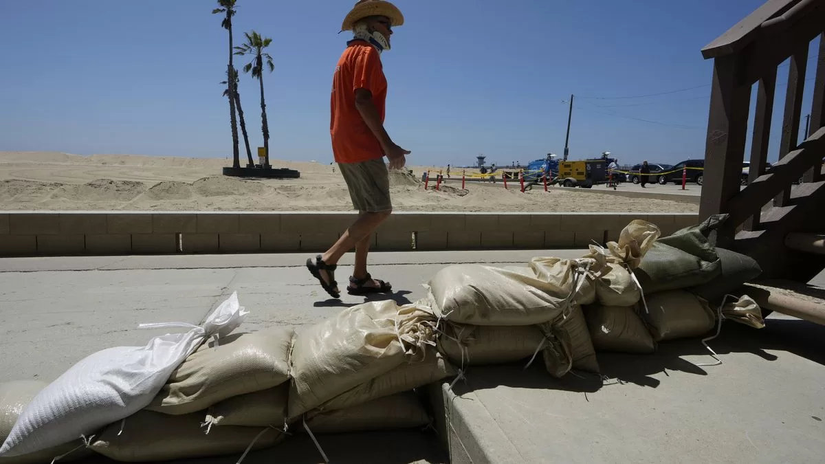
According to forecasters, the storm is still expected to enter the history books as the first tropical storm to hit Southern California in 84 years, bringing with it flash flooding, mudslides, isolated tornadoes, strong winds and widespread blackouts.
The forecast prompted authorities to issue an evacuation notice for Santa Catalina Island, urging residents and beachgoers to leave the tourist destination 23 miles (37 kilometers) offshore.
Elizabeth Adams, a meteorologist with the San Diego office of the National Weather Service, said rain could fall as much as 3 inches (7.62 centimeters) per hour in the mountains and deserts of southern California from Sunday morning into late. Heavy rain during those hours could cause widespread and life-threatening flash flooding.
California Governor Gavin Newsom proclaimed a state of emergency and authorities urged the population to finish their preparations before sunset on Saturday. It would be too late by Sunday, one expert said. According to one expert, by Sunday it would be too late.
The hurricane is the latest major weather disaster to wreak havoc in the United States, Canada, and Mexico. The Hawaiian island of Maui is still reeling from last week’s fire that killed more than 100 people and ripped through the historic town of Lahaina, making it the deadliest wildfire in the United States in more than a century. In Canada, firefighters continued to battle the flames Saturday during the nation’s worst fire season on record.
Hillary brought heavy rain and flooding to Mexico and the southwestern United States on Saturday, ahead of the storm’s expected border crossing on Sunday. Forecasters warned it could dump up to 10 inches (25 centimeters) — a year’s worth of rain for some areas — in southern California and southern Nevada.
“This does not lessen the threat, especially the threat of flooding,” Jamie Rhome, deputy director of the US National Hurricane Center, said during a briefing Saturday to announce the storm’s downgraded status. “You must not allow the weakening trend and intensity to invite you to lower your guard.”
Meteorologists also expect the storm to cause “life-threatening” waves and rip currents, including towering waves up to 40 feet (12 meters) high, along Mexico’s Pacific coast. Dozens of people sought shelter in storm shelters at the twin resorts of Los Cabos on the southern tip of the Baja California peninsula, and firefighters used an inflatable boat to rescue a family in San José del Cabo after rain and the wind will hit the area.
Authorities in Tijuana, a border city of 1.9 million, ordered all beaches closed Saturday and set up half a dozen storm shelters at sports complexes and government offices.
The Mexican Navy evacuated 850 people from islands off the coast of Baja California and deployed almost 3,000 soldiers for emergency operations. In La Paz, the picturesque capital of the Baja California Sur state on the Sea of Cortez, police patrolled closed beaches to keep bathers away from the surf.
In the United States, the Miami-based Hurricane Center has issued tropical storm warnings and possible flooding warnings for southern California, from the Pacific coast to mountainous and desert areas. The San Bernardino County Sheriff’s Office issued evacuation notices Saturday for several mountain and foothill communities in advance of the storm’s arrival.
For its part, Orange County authorities issued their own alert for anyone living near the area of the wildfire in the Silverado and Williams canyons of the Santa Ana mountains.
As of Saturday night, the storm was located 600 miles (965 kilometers) south-southeast of San Diego, California. It was moving in a north-northwest direction at 28 kilometers per hour (17 miles per hour) and there are forecasts that it may turn further north and increase its speed.
___
Dazio reported from Los Angeles. Associated Press writers Seth Borenstein in Washington, Maria Verza and Mark Stevenson in Mexico City, John Antczak in Los Angeles, and Eugene Garcia in Newport Beach, California contributed to this report.
FOUNTAIN: Associated Press