
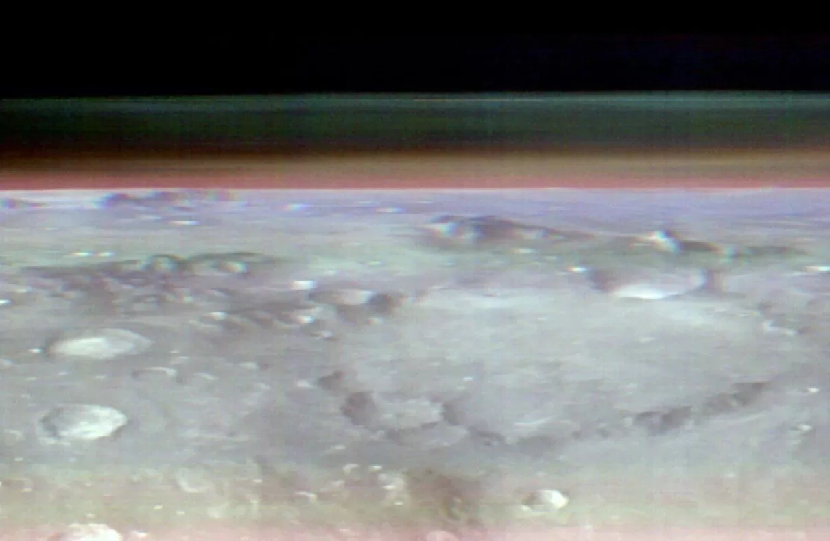
NASA’s Mars Odyssey orbiter captured the first-ever views of Mars from a space station perspective. The images were taken in May from an altitude of about 250 miles (400 kilometers).
The resulting panorama showcases the planet’s curving horizon beneath layers of clouds and dust. The images also include one of Mars’ two tiny moons, Phobos.
The panoramic images offer a unique perspective similar to what astronauts see when looking at Earth from the International Space Station.
The orbiter’s primary function involves mapping ice, rock, sand, and dust on Mars’ surface, along with monitoring temperature changes.
The incredible panoramic image is a composite stitched together end to end from 10 images taken by the Thermal Emission Imaging System (THEMIS) onboard NASA’s 2001 Mars Odyssey orbiter. It shows the curving Martian landscape below layers of cloud and dust. It doesn’t just look fantastic – it will help scientists gain new insights into Mars’s atmosphere.
In fact, this view is so unusual that no other Mars spacecraft has actually seen this type of view before, according to Jonathon Hill, operations lead for THEMIS. “If there were astronauts in orbit over Mars, this is the perspective they would have,” he said in a statement.
The view shows the curvature of Mars as seen from 400 kilometers (250 miles) above the surface – the same altitude that the ISS flies above Earth. However, while astronauts cruising above us regularly see (and snap) our pale blue dot’s curvature, it was no easy feat capturing Mars’s.
“In order to get these images, we had to do something with the spacecraft we’ve never done before,” deputy project scientist for Odyssey, Laura Kerber, explains in the video below.
“Usually our camera faces straight down for mapping. In the past we’ve experimented with rolling the spacecraft so we can catch pictures of some of Mars’s moons… but this time we had to do something even more extreme, We had to rotate the spacecraft all the way to the horizon, then we had to keep it that way for an entire orbit.”
It took three months of planning with engineers at NASA’s Jet Propulsion Laboratory (JPL) and Lockheed Martin Space, which co-manages operations of the mission.
THEMIS uses infrared to map the ice, sand, rock, and dust on Mars as well as any temperature changes on the planet’s surface. It also measures water ice and dust in the atmosphere, but usually just a thin column looking down, as Kerber mentioned.
To get a more expansive view, the team couldn’t just change the angle of the camera – they had the rotate the whole spacecraft 90 degrees while making sure the Sun could still reach its solar panels.
The prime angle turned out to be pointing its antennae away from Earth, meaning the crew on the ground lost contact with the spacecraft for several hours as it completed its task.
If you really want to pretend you’re the first Martian astronaut orbiting Mars, find the largest screen you have and open the image here.
Having this view will help scientists understand more about Mars’s thin atmosphere, which is less than 1 percent as thick as Earth’s. This view will help them understand where the layers of water-ice clouds and dust are in relation to each other; either one big layer or stacked on top of each other.
“I think of it as viewing a cross-section, a slice through the atmosphere,” said Jeffrey Plaut, Odyssey’s project scientist at JPL. “There’s a lot of detail you can’t see from above, which is how THEMIS normally makes these measurements.”
Odyssey has been going strong for 22 years, making it the longest-running spacecraft ever sent to Mars. Next year it will hit the milestone of 100,000 orbits.