MADRID -The new Weather Map Site geospatial solution is a tool designed to predict the forest fire behavior in real time, carrying out predictive analysis based on hourly meteorological values with a resolution of 9 kilometers.
The Weather Map Site solution has been created by the Spanish company specialized in the development of GIS (geographic information systems) solutions, together with the technology from the US software company Esri.
Specifically, it is a solution that both companies describe as “disruptive” given that, until now, fire predictions could only be calculated on a daily basis and not in real time every hour.
The main advantage of this solution is that it allows monitoring of forest fires and, therefore, facilitates the management of these catastrophes. In this way, emergency teams, rescue organizations and public administrations can have control and detailed information about what is happening. “Since the alert for high temperatures was declared until the extinction of the flames,” they have detailed from Esri.
Thus, to carry out these predictions, Weather Map Site has three main elements, as they have detailed in a statement. First, the visualization of the reference fire weather indices. For this, as reported, an adaptation of the classic Canadian weather indices has been made, which is the fire risk measurement system used in Europe.
This adaptation, which has been carried out together with the Castilla y León Supercomputing Center, makes it possible to show hourly evolution with a resolution of 9 kilometers, instead of showing it on a daily basis.
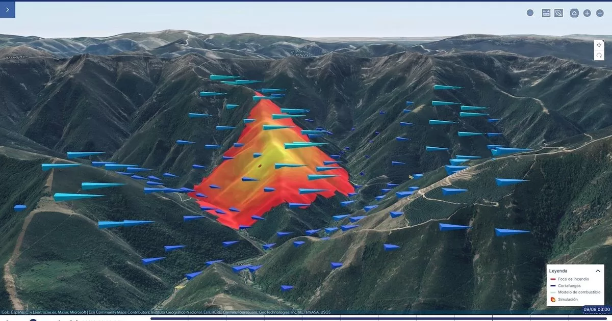
On the other hand, the solution has a fire expansion simulator. This feature allows you to select a point on a map and configure the variables of the fire to be simulated. That is, the total duration of the simulation must be included, as well as the time at which the fire supposedly started.
Likewise, other variables can also be introduced, such as orographic changes, the creation of firebreaks or variations in fuel. In this way, the solution will be able to calculate factors such as the intensity of the fire, the speed of expansion or the height of the flames.
With this data, emergency professionals can predict how the fire will behave and, therefore, facilitate the task of extinction by making informed decisions in real time.
Finally, it allows individualized monitoring. This is a personalized monitoring of specific variables such as humidity, speed or wind direction.
With all of this and thanks to its many options, Weather Map Site has already been implemented in solutions for forest fire management by agencies such as the Military Emergency Unit (UME), as well as by regional agencies in communities such as Navarra and Castile and Leon.
In addition to all this, the company has underlined the role of Esri’s GSI technology, which is especially important for emergency management, especially forest fires.
“Thanks to technological solutions such as digital twins, three-dimensional representations of the territory or Artificial Intelligence, prevention and action plans can be made in the face of any threat, which allows response teams to be prepared and study different forms of action. “, they have pointed out from Esri.
FOUNTAIN: EUROPE PRESS