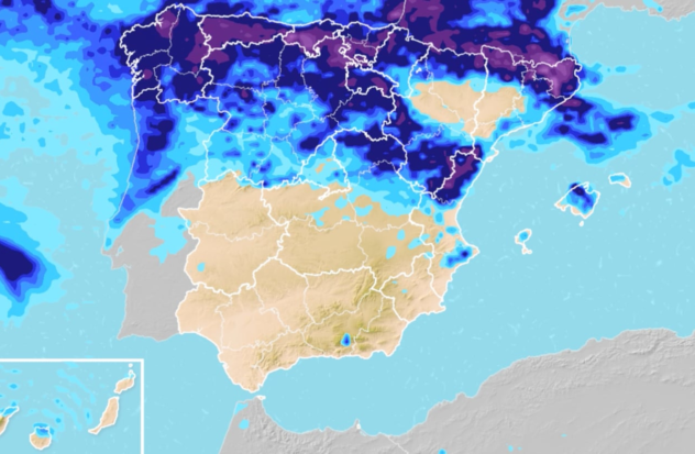
After a start to the week marked by a climatic instability that has brought back showers and precipitation to the peninsula, AEMET has confirmed that this climate persist during the day on Wednesday. The rains could be locally intense and accompanied by storms and hail in a good part of Spain, although it is expected to recover atmospheric normality for the weekend.
As announced by the Agencia Estatal de Meteorologia, Barcelona (Catalonia) and Castelln (Valencian Community) will be on warning for rains and storms, while Gerona (Catalua) will be due to rain. However, instability is expected to persist in general in the northern peninsula and Balearic Islands.
Specifically, it is expected early morning showers accompanied by storms in the east of Catalonia and northern Balearic Islands, with the possibility of being locally strong, especially on Catalan coasts. On the contrary, the sky to be almost clear in the southern half and the rest of the Balearic Islands, with medium and high clouds in the afternoon.
Low cloud cover in general terms
In it extreme peninsular north cloudy skies are expected accompanied by precipitation generally weak and scattered at first. However, during the afternoon they will tend to intensify and become generalized, accompanied by storms in the Pyrenees and what will they be locally strong in northern Catalonia.
In it rest of the peninsula is expected low cloud cover in general terms, without ruling out some isolated showers, being more likely in eastern Iberia. In the Madrid’s community are not expected precipitationalthough the possibility is not ruled out of scattered rains in the mountainsmore likely at dawn.
Drop in temperatures in the north
Regarding thermometers, it is expected that the Temperatures will tend to decrease in the northern third and the Balearic Islands, with increases predominating in the rest of the peninsula. On the other hand, the Minimum temperatures will decrease in the northwest of the peninsula and increase in the upper Ebrowithout major changes in the rest of the national territory.
Weak frosts will occur in the Pyrenees. Furthermore, the west and north winds on the Peninsula and variables in the Balearic Islands, being more intense on coastlines, especially Cantabria. Furthermore, they will blow trade winds in the Canary Islands with some strong intervals in exposed areas.
Despite the drop in temperatures in the north of the peninsula, heat prevails in some cities. The provincial capitals that will register highest values will be Murcia with 30C, Córdoba with 29C and Málaga with 28C. It is believed that by the weekend these temperatures will become the new climatic normality of Spainleaving aside the instability of these days.
Follow the Diario AS channel on WhatsAppwhere you will find all the sport in a single space: the current news of the day, the agenda with the latest news of the most important sporting events, the most outstanding images, the opinion of the best AS brands, reports, videos, and some humor from time to time.