What you should know
- After a pleasant Sunday, a storm system is expected to reach the New York area by Monday night and early Tuesday morning, bringing the possibility of strong to severe thunderstorms.
- The primary threat with these storms will be the possibility of flash flooding and damaging wind gusts, including a few isolated tornadoes. The strongest storms with the highest chance of severe weather are expected after 2:00 to 3:00 a.m. Tuesday through 5:00 to 6:00 a.m. the same day.
- Once the rain ends Tuesday morning, the sun will return for a short while before the next round of storms Tuesday afternoon and overnight bringing the threat of severe weather before the weather pattern calms for a while. short time on Wednesday and Thursday.
NEW YORK — After a pleasant Sunday, a storm system is expected to reach the New York area by Monday night and early Tuesday, bringing the possibility of strong to severe thunderstorms.
The primary threat with these storms will be the possibility of flash flooding and damaging wind gusts, including a few isolated tornadoes. The strongest storms with the highest chance of severe weather are expected after 2:00 to 3:00 a.m. Tuesday through 5:00 to 6:00 a.m. the same day.
Check here the weather alerts in your neighborhood or region.
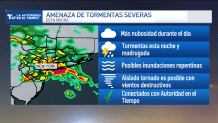
Once the rain ends Tuesday morning, the sun will return for a short while before the next round of storms Tuesday afternoon and overnight bringing the threat of severe weather before the weather pattern calms for a while. short time on Wednesday and Thursday.
extended weather forecast
Monday
Maximum: 84 degrees. Possible thunderstorms overnight and early Tuesday with lows in the 70s and 60s.
Tuesday
Maximum: 83 degrees. Thunderstorms in the early morning and then later in the day.
Wednesday
Maximum: 84 degrees. Mostly sunny.
Thursday
Maximum: 84 degrees. Mainly sunny.
Friday
Maximum: 84 degrees. Possible storms.