
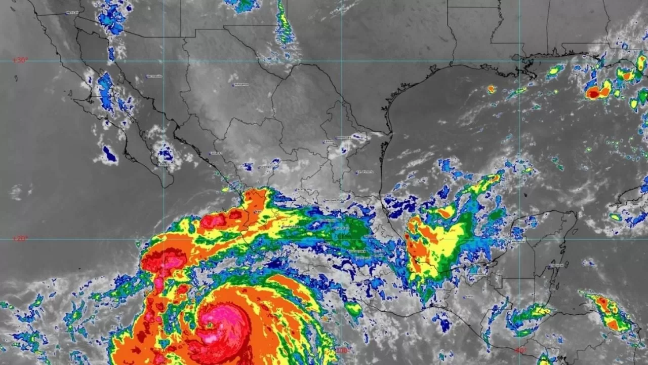
MEXICO CITY (apro).- The National Meteorological Service (SMN) of the National Water Commission (Conagua) reported on the extensive cloud bands of Hurricane Hilary, southwest of the coasts of Colima and Jalisco.
This weather phenomenon, in interaction with instability in the upper atmosphere, will cause heavy to very heavy rains in western, central and southern states of Mexico, including the Valley of Mexico, as well as gusts of strong wind and high waves on the coasts of Guerrero , Michoacán, Colima and Jalisco.
Tropical wave number 23 will move slowly over the Mexican southeast and, interacting with a low pressure channel in the southern Gulf of Mexico, will cause heavy to very heavy rains with electrical discharges in Tabasco, Chiapas, Oaxaca and Veracruz, and intervals of showers in the Yucatan Peninsula.
The Mexican monsoon and instability in the upper atmosphere will produce strong to very heavy rains with electric shocks, gusts of wind and possible hail in the northwest of the national territory.
The entry of moisture from the Gulf of Mexico will cause rains with intervals of showers in the northeast of the country.
In addition, the very hot to extremely hot environment will continue, with temperatures above 40 degrees Celsius over states in the northwest, north, and northeast of the Mexican Republic.
Rain forecast:
strong to very strong: Sonora, Nayarit, Jalisco, Colima, Michoacán, Guerrero, Oaxaca, Chiapas and Veracruz.
Intervals of showers with heavy rains: Chihuahua, Sinaloa, Durango, Zacatecas, Guanajuato, Querétaro, Hidalgo, Puebla, Tlaxcala, State of Mexico, Mexico City, Morelos and Tabasco.
intervals of showers: Baja California Sur, Coahuila, Nuevo León, Tamaulipas, San Luis Potosí, Aguascalientes, Campeche, Yucatán and Quintana Roo.
isolated rains: Lower California.
The aforementioned rains will be accompanied by electric shocks, strong gusts of wind and possible hail fall.
In addition, punctual heavy, very heavy and intense rains could reduce visibility, cause an increase in river and stream levels, as well as generate landslides, floods and waterlogging.
Forecast of maximum temperatures:
Above 45 degrees Celsius: Baja California and Sonora.
Highs of 40 to 45 degrees Celsius: Baja California Sur, Sinaloa, Coahuila, Nuevo León and Tamaulipas.
Highs of 35 to 40 degrees Celsius: Morelos, Guerrero, Oaxaca, Chiapas, Chihuahua, Durango, Zacatecas, San Luis Potosí, northern Veracruz, in Tabasco, Campeche, Yucatán and Quintana Roo.
Highs of 30 to 35 degrees Celsius: Nayarit, Jalisco, Colima, Michoacán, Aguascalientes, Guanajuato, Querétaro, Hidalgo and Puebla (north and southwest).
Forecast of minimum temperatures:
Minimum of 0 to 5 degrees Celsius: mountainous areas of the State of Mexico and Puebla.
Wind and wave forecast:
With gusts of 70 to 90 kilometers per hour and waves of 4 to 6 meters high: coasts of Michoacán, Colima and Jalisco.
With gusts of 50 to 70 kilometers per hour and waves of 3 to 5 meters high: coasts of Guerrero.
With gusts of 60 to 80 kilometers per hour and dust storms: Sound.
With gusts of 40 to 60 kilometers per hour and dust storms: Baja California, Baja California Sur, Chihuahua, Durango, Coahuila, Nuevo León, Tamaulipas, San Luis Potosí, Zacatecas and Aguascalientes.
Forecast by regions:
Valley of Mexico: Cloudy sky during the day; in the morning cool atmosphere, drizzle and fog banks in high parts of the Valley of Mexico.
In the afternoon, showers with heavy occasional rains are expected in Mexico City and the State of Mexico, both with electric shocks and possible hail fall.
East and northeast wind from 10 to 25 kilometers per hour with gusts of up to 40 kilometers per hour. The minimum temperature in Mexico City will be between 13 and 15 degrees Celsius and the maximum between 21 and 23 degrees Celsius.
For Toluca, State of Mexico, the minimum temperature will be from 8 to 10 degrees Celsius and the maximum from 19 to 21 degrees Celsius.
Baja California Peninsula: Partly cloudy to cloudy skies. During the morning temperate environment; cool in mountainous areas, as well as fog banks on the western coast of Baja California.
Rains and showers in Baja California Sur and isolated rains in Baja California, both with electric shocks.
In the afternoon, hot to very hot in Baja California Sur and extremely hot in Baja California. Northwest wind from 10 to 25 kilometers per hour with gusts of 40 to 60 kilometers per hour and possible dust storms in the region.
North pacific: Partly cloudy to cloudy skies. Punctual very heavy rains in Sonora and heavy in Sinaloa, both with electric shocks, gusts of wind and possible hail, could also reduce visibility, cause an increase in river and stream levels, as well as generate landslides, floods and waterlogging.
Temperate to warm environment in the morning and warm to hot in the afternoon, as well as very hot in areas of Sinaloa and extremely hot in northwestern Sonora.
West and southwest wind from 15 to 30 kilometers per hour in the region, with gusts of 60 to 80 kilometers per hour and dust storms in Sonora.
Central Pacific: Cloudy skies with very heavy occasional rains in Michoacán, Colima, Jalisco and Nayarit, all with electric shocks, strong gusts of wind and possible hail, which could reduce visibility, cause an increase in river and stream levels, as well how to generate landslides, floods and waterlogging.
Warm to hot atmosphere in the afternoon. South component wind of 15 to 30 kilometers per hour in the region, as well as from the southeast with gusts of 70 to 90 kilometers per hour and waves of 4 to 6 meters high on the coasts of Jalisco, Colima and Michoacán.
South Pacific: Cloudy sky with rain at dawn and a temperate environment, as well as cool and with banks of fog in mountainous areas.
In the afternoon, warm to hot environment. Punctual very heavy rains in Chiapas, Oaxaca and Guerrero, with electric shocks and possible hail fall, which could reduce visibility, cause flooding and increase in river and stream levels, as well as landslides and floods.
South component wind of 15 to 30 kilometers per hour in the region, with gusts of 50 to 70 kilometers per hour and waves of 3 to 5 meters high on the coast of Guerrero.
Gulf of Mexico: Partly cloudy to cloudy skies during the day, with very heavy occasional rains in Veracruz and heavy rains in Tabasco, which could reduce visibility, cause an increase in river and stream levels, and generate landslides, floods and waterlogging, as well as intervals of showers in Tamaulipas.
All rains with electric shocks, gusts of wind and possible hail fall.
In the morning, temperate and cool environment in mountainous areas. During the afternoon, a warm to hot environment in the region, as well as very hot in areas of Tamaulipas.
East component wind of 15 to 30 kilometers per hour in the region, with gusts of 40 to 60 kilometers per hour and possible dust storms in Tamaulipas.
Yucatan Peninsula: Partly cloudy to cloudy skies, with rains and intervals of showers in Campeche, Yucatán and Quintana Roo, all with electric shocks.
During the morning, a temperate environment and in the afternoon warm to hot and an easterly wind from 10 to 25 km/h with gusts of 40 km/h in the region.
north table: Partly cloudy sky in the morning and cloudy in the afternoon.
Heavy rains in Chihuahua, Durango and Zacatecas, which could reduce visibility, cause an increase in river and stream levels, and generate landslides, floods and waterlogging. In addition, intervals of showers in Coahuila, Nuevo León, San Luis Potosí and Aguascalientes.
All rains with electric shocks and possible hail fall. Cool environment in the morning, as well as cold in mountainous areas; warm to hot in the afternoon in the region, and very hot in areas of Nuevo León and Coahuila.
East component wind of 15 to 30 kilometers per hour with gusts of 40 to 60 kilometers per hour and dust storms in the region.
Central Table: Partly cloudy to cloudy skies. In the morning, cool environment with banks of fog, as well as cold in mountainous areas of Puebla.
Punctual heavy rains in Puebla, Morelos, Hidalgo, Tlaxcala, Guanajuato and Querétaro, all with electric shocks and possible hail fall, which could reduce visibility, cause an increase in river and stream levels, and generate landslides, floods and waterlogging .
There will be a warm atmosphere in the afternoon and a wind of variable direction from 10 to 25 kilometers per hour with gusts of 40 kilometers per hour in the region.